Political geography is the differences between people in there belief in government over a broad range of space. You can look at political views in many different scalar quantities. You can look at and analyze voting and policy matters patterns of people anywhere from one voting district to Carson County to the State of Nevada or on the nation as a whole. Political geography looks at people and their government on different scales, political cartography maps people and their government at a multitude of scales. The basis of political cartography is voting, be it on a specific candidate or on a policy or on a party, or a party’s platform, voting is the primary form of political mapping. Mapping voting patterns.
By mapping these patterns we can see where people are and what there views on everything are. Based on that analysis we can then make deductions about other things on the populous. If, for example, we see and intensely high number of republican voters in an area we may deduce an influx of a certain type of person from that area, and then we can deduce why that area has those types of people. For example, Douglas county Nevada voted republican for pretty much every possible ballot question and office last election. I know from talking with such people that most ranchers are republican. So based on the land use and the available land in Douglas county I would say it has a higher percentage of ranchers than say lawyers or bankers.
Political cartography is a great way to map the U.S. and each state and discover what people believe in each of those regions. You can tell California is more liberal than Nevada based on its voting patterns. Etc.
Michael F. Goodchild does an excellent job in telling of how GIS and politics are affected by each other in his article Just the Facts, Political Geography Quarterly, 10(4): 335-449. This article helps explain many of the fallacies of GIS and its applications and gives a brief overview of political geography.
Basically political cartography maps out how people think about government. This can then indicate how people think in general. This is a great help to human and cultural geographers who are trying to map why people are where and who is where they are. It has become another tool in the democratic world to help indicate where who is and why.
In Vladimir Kolossov's article "American geography and the rise of political geography in Russia". Kolossov explains how political geography and political cartography didn’t exist when the communist government was in control, but as the soviet block fell apart and a democratic system was put into place American geographers and emerging Russian geographers began to map out the new system. This excited American geographers because it enabled them to see how people moved, voted and thought based on where they were from the beginning of the new system. American and Russian geographers monitored and mapped voting patterns and came to many conclusions. The point of the matter being, some governmental systems simply are not good environments for certain science fields. Apparently communism is bad for political geography. But this also makes me think, if this is the case, what sciences or thought process are we missing being democratic? Capitalistic? What could we think about without such governmental controls? I believe it would have mostly to do with people, since that is what government controls, people. So I think government affects the sciences of the people; psychology, sociology, anthropology and of course human geography. But governmental controls could are found that reduce the productivity of biologists, chemists, geneticist, and quite a number of other fields. They do this because the government deems their research unethical. I read an article last week about a research project at Oregon State that was modifying the DNA of rams which would only mount other rams. They were trying to modify the genetic material enough to encourage the rams to mount sheep. This was halted by the governing body because it was encouraging research on gays and could have a negative reaction from the gay community.
Political cartography will live as long as there is a decent electoral body to map. If nobody votes, if nothing is passed, if no issues present themselves before congress, then political cartography will die.
Citation:
Kolossov, Vladimir. 2004. “American geography and the rise of political geography in Russia” GeoJournal 59: 59 – 62.
Monday, March 26, 2007
Thursday, March 8, 2007
The Earth, Moon, Stars and Mars; Now in 3D!
There’re two programs I like to use when I look at three dimensional cartography today, I use one of two programs; either Google Earth, or NASA World Wind. (Follow the links to download these free programs.) These are both wonderful programs and do an enormous amount, but each is slightly different.
Google Earth does a wonderful job of displaying earth in all of its capacities. It represents all earth systems well, some better than others, but all in all it is an incredibly useful program to do research. NASA’s World Wind gives viewers most of the same information with a few differences. But again, this program has a plethora of information to display to its users.
The main differences between these two programs become quickly apparent to most users. Google Earth is set up to handle a cultural geographic aspect of earth, whereas NASA’s World Wind is set up to view earth from a physical geographic point of view. Some of the basic features of Google Earth include dining stops, roads, sightseeing information, lodging, and transportation. World Wind has tools that allow you to look at current precipitation patterns, wind patterns, pressure heights, and ocean current movement. Each program has a search program to locate specific cities or addresses, but Google Earth’s has much more detailed information and incorporates Google Maps into the process. This makes for a very easy way to plan a trip route and decipher how different places work culturally. Some of the advantages of World Wind besides the metrological earth systems include current cloud cover information, recent and current disasters, (such as dust storms, fires, earth quakes, hurricanes, tornadoes, etc…) and different projections of use on the three dimensional level. World Wind also has a tool known as Place Finder, which makes use of Yahoo maps to display similar travel and location information compared to Google Earth. Another fun feature utilized by World Wind is some other layers besides Earth. You can cruise around the moon, Jupiter, Mars, and one of Jupiter’s moons. These may not be useful, but they do provide hours of entertainment (for map geeks like me.)
Google Earth

NASA World Wind

If you want to compare these two three dimensional programs to some two dimensional references, you could say that Google Earth runs much like Rand McNally atlases; it shows human cultural activity, where World Wind acts more like the National Geographical atlas, showing earth systems features.
Three dimensional cartographic programs in general are evenly useful and can show a plethora of information and have many different utilities within them. These programs are a recent addition to a vast cartographic library of resources. These programs are all derived from the same information as a flat wall map.
Another type of three dimensional cartography, which in today’s world of technology is commonly overlooked, is globes. Much how Google Earth was derived from a program like Google Maps, (a 2 dimensional program) globes were derived from flat paper maps. Globes are a great way to view our earth, they show viewers many misconceptions made by looking at maps. For example, I know a girl who would swear on her mother’s grave that Alaska was an island just east of Hawaii and just west of Mexico. Sadly these perceptions of our earth do happen, however globes silence many questions people have about how the earth actually is. Globes are the most accurate tangible reference map people can use today, and I believe they are fundamental in human understanding of earth.
So if you need a basic understanding of this grand world of ours; dust off an old globe and spend a few hours perusing its contents. If you need a detailed route on how to get to aunt Sally’s in New York and what to do when you get there and where to stay and eat on the way and what airport to fly out of and intimate directions on all of these things, go to Google Earth. If you want to know what the five hundred mille-bar height of the atmosphere four days ago was and if it’s going to snow this weekend then tryout World Wind. All in all, you can’t go wrong with three dimensional cartography and the myriad of informative doors it opens up.
Wednesday, March 7, 2007
Artistic or useful?
Old maps, they can be priceless commodities people steal to make money as what has happened countless times, and is very lucrative for those who get away with it. A great example of old map theft is portrayed in Miles Harvey’s The Island of Lost Maps: A true storey of Cartographic Time. What this tells me about ancient maps is that well done historical maps have become priceless commodities to history buffs and appreciators of fine art. Old, historical, good maps are hand drawn, and incredibly detailed; this is what makes them so artistic. This is not to say all old maps are perfect, in fact, most old maps are outdated and are worthless for reference. Old maps are useful to historians who wish to research what happened, but if you have a historical map of a place, you will indubitably get lost.
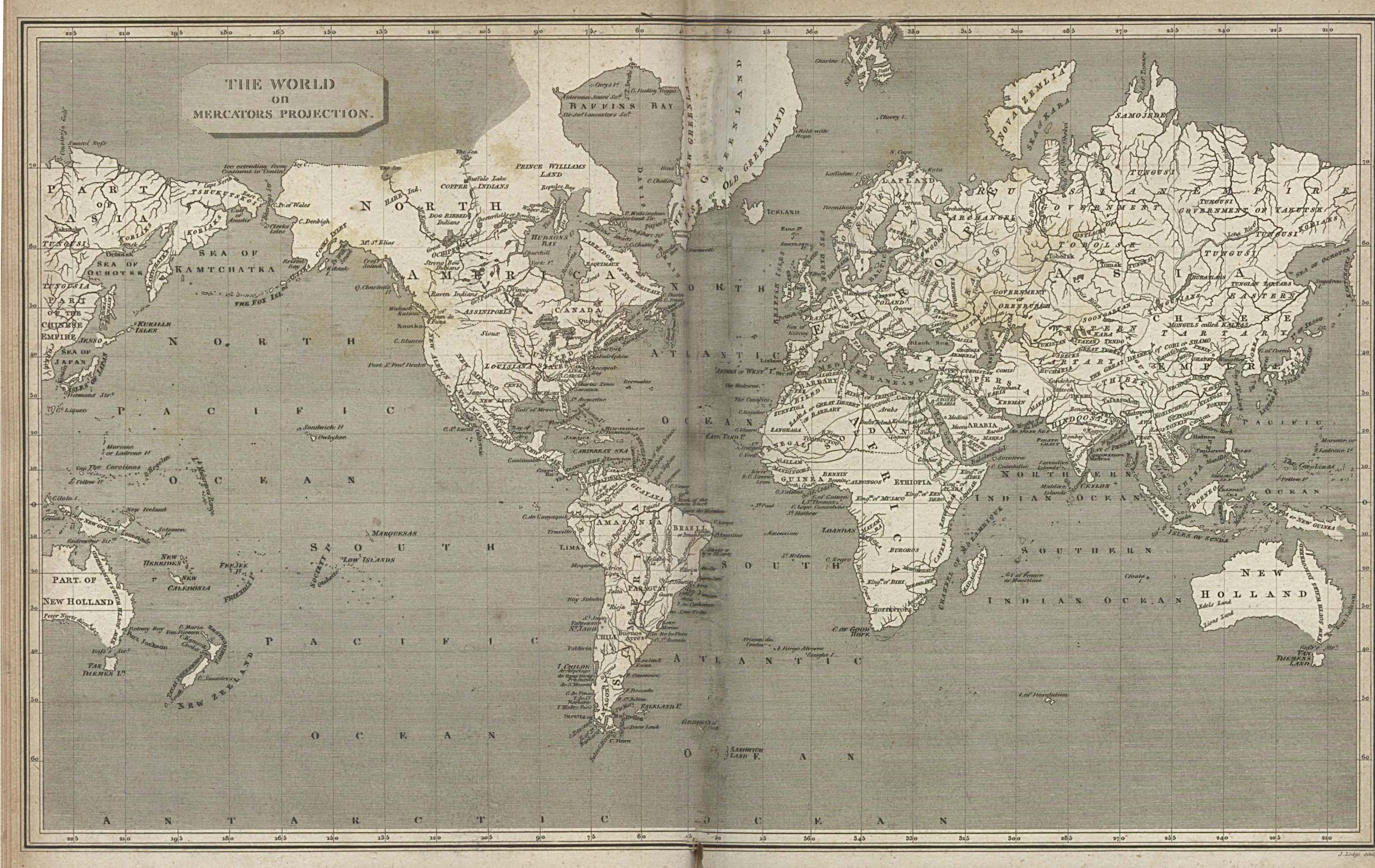
The map to the right is a hand-drawn mercator projection from 1820. This map demonstrates artistic design in antique maps and how precise (if not accurate) the cartography was
Some new maps are of old things. This is also very useful for researchers; it can show visually what happened in a clear concise way. Historical cartographers and historical geographers specialize in this area of study.
New maps, as compared to old maps, are very much less valuable to art critics, but are intensely useful to those wishing to drive from Beeville, Texas to Wells, Nevada. New mapping programs like Google Maps are very useful and very easy to find and use for the every day person. New maps are used to display information visually, but most historians have no interest in them.
National Geographic, or Rand McNally both have atlases to show the populous information, the National Geographic atlas shows useful information about the whole world and is incredibly detailed, whereas Rand McNally’s road atlas is more for people who wish to hit the road and travel across the U.S. It focuses more on the major road systems and towns on them then the smaller rural areas which most people on a road trip will not even notice.
Old Map Links:
New Map Links:
Subscribe to:
Comments (Atom)


